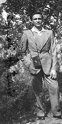
Marco Zagnoli recently wrote to me from Italy about his family’s support for Allied airmen in 1943–44.
“My father told me that he—at the age of sixteen—helped British airmen who were evaders or escaped from prison camps to pass the lines and reach the Allied troops,” Marco said.
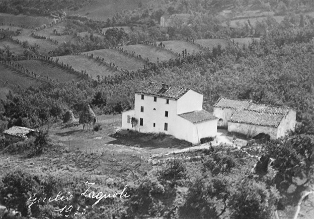
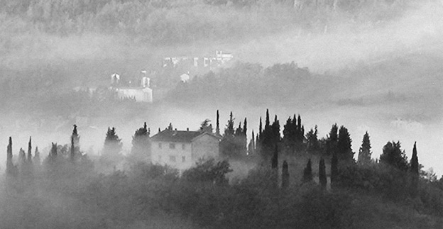
“Also, my grandfather provided help, hiding the airmen at our family farm called Poggio di Casola, Castel di Casio village, near Porretta Terme (Bologna).
“On the British military maps of the area—to which my father could get a look—our farm was marked as ‘a family that helps British troops,’ or something similar.”
The airmen, Marco explained, turned up individually at the farm over time.
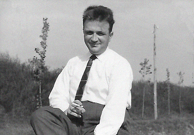
“My father guided airmen more than ten times—maybe twelve.
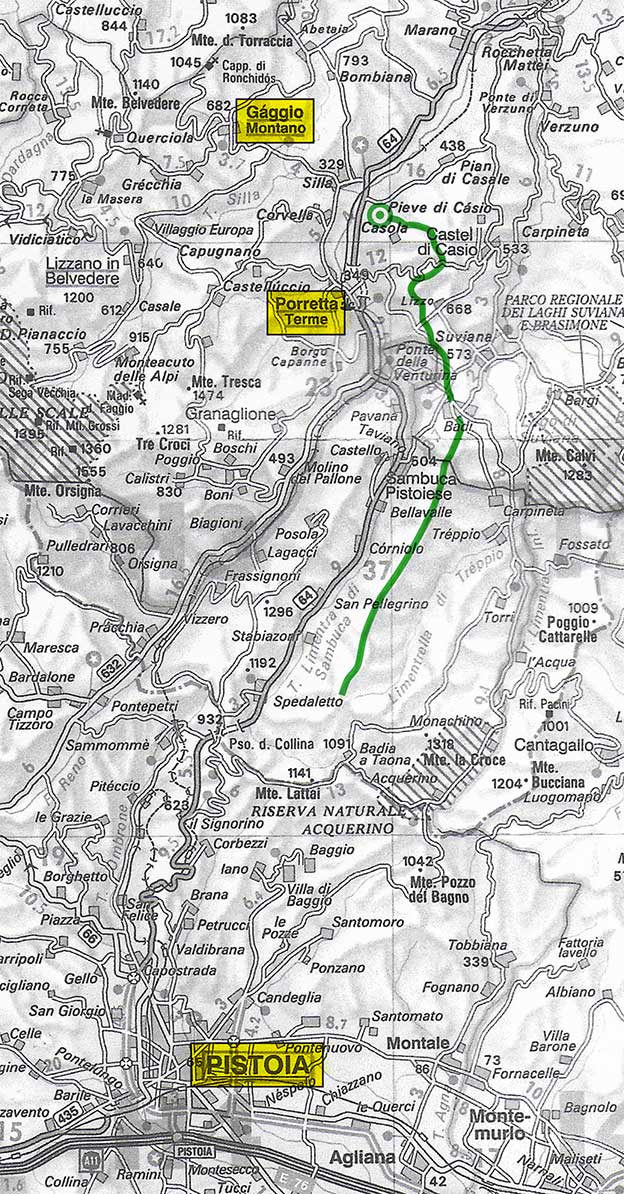
“After hiding each British soldier and refreshing him, in the early morning (3.00 AM), my father led him into the chestnut woods, reaching and staying on the ridge of the mountains in order to avoid German soldiers. They passed on the ridge over Suviana Lake, Badi, Taviano, and continued south towards Pistoia.
“As a meal they only had a loaf of bread and at times a slice of cheese.
“Once on the hills surrounding Pistoia, my father left the airman and went back to Poggio by way of the chestnut woods.
“My father didn’t know the way the airman had to go in order to cross the front line and reach the Allies, but I think the airman knew the next place to go in Tuscany.”
The mountains Antonio lead the airmen though were in the northern sector of the Apennines (Appennino settentrionale), specifically the Tuscan-Emilian subchain.
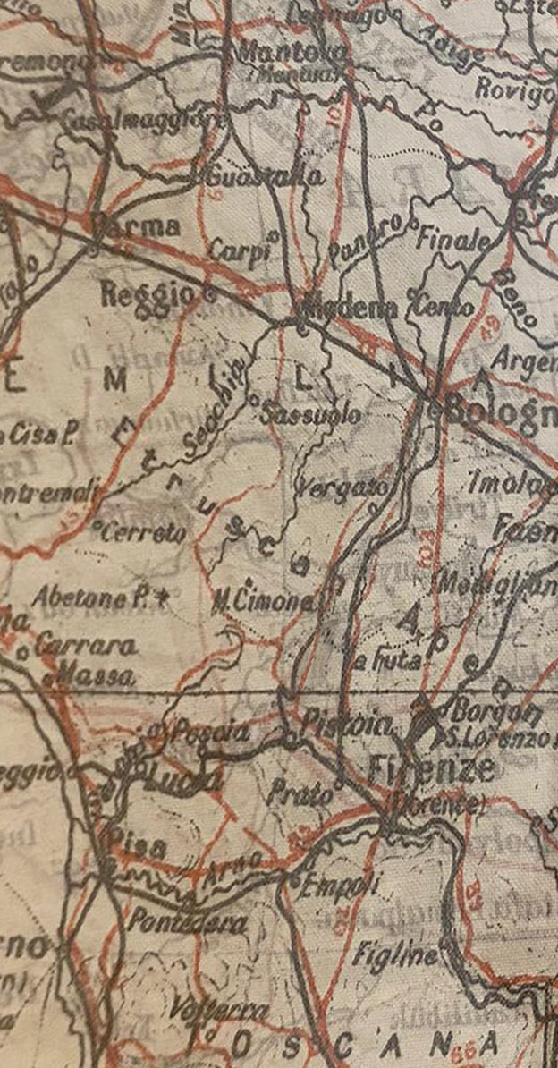
It occurred to me that the map the airmen were carrying might be a silk RAF pilot’s map, or “escape map.”
During the war, Allied paratroopers were dropped behind enemy lines in Italy on special missions and to make contact with the Italian resistenza. On the ground, the men were on their own. A map of the area, printed on silk, was standard issue for these men. It showed local features, such as roads, rivers, and villages.
My friend Kirsty McBeth had recently purchased one of these vintage maps at auction. She kindly photographed a section of the map for me that includes Pistoia and Bologna— and the area between, where Poggio di Casola was located. Although the map provides a great deal of information, it’s not detailed enough to show individual farms, so the nature of the “military map” Antonio caught a glimpse of remains a mystery.
I asked Marco if he was confident the soldiers were airmen.
“Yes, absolutely,” he answered. “Also, my uncle confirmed it.
“Each airman came by himself, not with other airmen, in different periods.
“Each soldier told the members of my family that he knew that to reach the Allied lines he had to ask for help, food, and hiding at a farm in Gaggio Montano (left bank of the Reno river) and then cross the river and ask for help, food, hiding at our farm (right bank of the Reno river), and then to be guided by a member of my family through the mountains to the Pistoia district.
“Our family doesn’t know how the airmen knew that at our farm—and at the farm in Gaggio Montano—they were sure to be helped and not betrayed. As a matter of fact, some of the neighboring farms (Prati, Torraccia) at that time were owned by fascists.
“The airmen all knew that my family was Christian and against fascists and Nazis. It was indicated on the maps, my father told me.”
Marco said no one in his family knew which one of the farms in Gaggio Montano provided assistance to the airmen. The airmen didn’t share that information with the family.
“The front line was constantly in the move,” Marco explained. “On their way north, the Allies set Pistoia free on September 8, 1944; Florence a week before; Arezzo on August 16th; Ancona on July 18th; and Perugia on June 20th.”
I asked Marco why he thought the airmen chose to travel south to cross the lines, rather than to make their way to Switzerland, the route chosen by many escapees in northern Italy.
He replied, “I have to point out that in 1943–45 the bridges over Po river (that divides in two parts the Padana plain (i.e. the main part of northern Italy) were either destroyed after bombing or strictly controlled by the Nazis. So if an Allied soldier found himself on the right bank of Po river, it was not possible—or was very, very dangerous—for him to cross the Po, reach the Alps, and then try to cross the border to get into Switzerland.
“The Padana plain didn’t offer many hiding places because it was—and still is—a flat land of fields with few woods. Moreover, the cities and towns were strongly controlled by Nazis and fascists.
“The option to go south was dangerous, but a soldier could find his way through woods and mountains, keeping away from towns and crowded places.
“Longer, but safer.
“And going south made it possible to cross over to land controlled by the Allied army, like your father did.”
Marco pointed out that a third option, staying put, was also dangerous for the airmen, as they ran a risk of being betrayed.
“The journeys would have taken place in the period starting August 1943 and ending in September 1944,” Marco said.
“I am sure of it, because:
“A. Before August 1943, my father and grandpa were in Milano. My grandpa was a railway worker and also a farmer/landowner of a tiny farm, and they suffered July’s aerial bombardments of Milan. They only went to Poggio in August, when the aerial bombardment was reduced. The rest of my family had yet to move.
“B. The Nazis occupied Porretta Terme in August or September 1943, and retreated in September 1944, after harsh fighting on the mountains north of Gaggio Montano and Riola, which faces Porretta Terme.
“C. On September 26, 1944, the Allied troops of the Sixth South African Armored Division conquered Passo della Collina (which means ‘the Hill’s Pass’) that links Bologna district with Pistoia district. Then, on October 10, 1944, the XI Battalion of the U.S. First Infantry Division set Porretta Terme free.
“From fall 1944 through spring 1945, five Sherman tanks were based on our hill and the soldiers lived with our family.
“All the members of my family have since referred to the period passed with the U.S. soldiers with a sense of gratefulness to the Americans who brought with themselves freedom, food, coffee, and cigarettes.
“My father died on February 1982. The only members of my family who were living during the war and are still living are my uncle (the youngest brother of my father) Umberto (born 1932), who was a boy during the war, and my second cousin Vittorio (born 1926).”
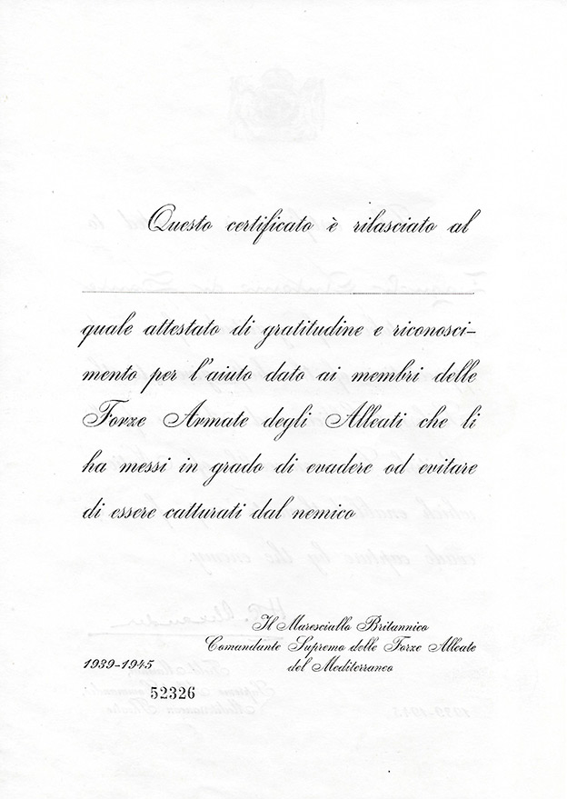
“I am in possession of a certificate of gratitude, signed by Field-Marshal H. R. Alexander, awarded to my father,” Marco continued.
“I had seen this certificate before, but unfortunately I had looked only at the back”—where the document has an Italian translation. “It was not completed, so I thought it was of no importance.
“I said to myself, ‘Why didn’t my father get this certification? Very strange.’
“Then last year, in putting old paperwork in order, I had a lucky strike and looked at the front.”
On the English-language side of the certificate is penned in stylish calligraphy the name “Zagnoli Antonio di Sante.”
“So I then started researching the story behind this certificate,” Marco said, “until a search on the internet led me to your site.”
“I suppose that the certificates—issued to a select group of Italians who had risked their lives to protect escaped British POWs and evaders—were issued after a preparatory phase, as the sequential number suggests.”
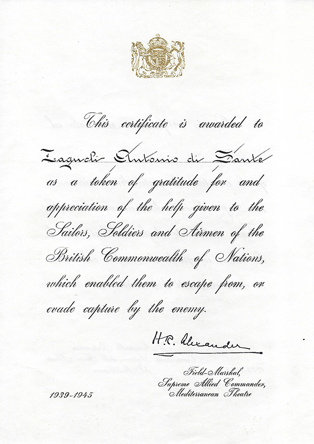
This certificate is awarded to Zagnoli Antonio di Sante as a token of gratitude for and appreciation of the help given to the Sailors, Soldiers, and Airmen of the British Commonwealth of Nations, which enabled them to escape from, or evade capture by the enemy.
H.R. Alexander
Field-Marshall,
Supreme Allied Commander,
Mediterranean Theatre
1939–1945